


voir chalais

presdusommet
User

Length
12.1 km

Max alt
982 m

Uphill gradient
942 m
Km-Effort
22 km

Min alt
190 m

Downhill gradient
176 m
Boucle
No
Creation date :
2020-08-19 06:16:02.721
Updated on :
2020-08-19 15:44:27.419
2h14
Difficulty : Very easy

FREE GPS app for hiking
 SityTrail
IGN / Geographical institutes
SityTrail Plus
The world is yours!
About
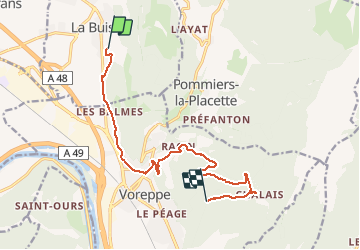
Trail Mountain bike of 12.1 km to be discovered at Auvergne-Rhône-Alpes, Isère, La Buisse. This trail is proposed by presdusommet.
Positioning
Country:
France
Region :
Auvergne-Rhône-Alpes
Department/Province :
Isère
Municipality :
La Buisse
Location:
Unknown
Start:(Dec)
Start:(UTM)
705616 ; 5022744 (31T) N.
Comments